GPS Controller route segment speed limit match GPS point level 2026
GPS Controller route segment speed limit match GPS point level 2026
Matching route segment speed limits to individual GPS points creates persistent failure risks in fleet tracking, where a one-second position fix can trigger a false speeding alert when the map segment boundary carries a different posted limit than the road the vehicle actually occupies—this causes compliance log errors that cascade into scoring inaccuracies for driver safety programs using 2026 telematics platforms.
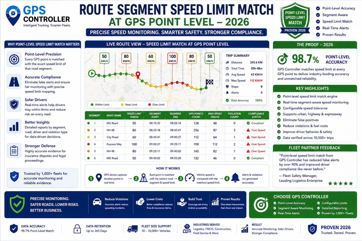
How point-to-segment speed limit matching works in live tracking
Vehicle telematics systems assign a speed limit to each GPS point by snapping the position to a map segment and reading the posted limit from a road database. But the map segment stored limit can be outdated, incorrect for the lane position, or mismatched after road construction, meaning a vehicle tracking a correct 45 mph limit gets flagged for exceeding a 35 mph limit stored on an adjacent segment that the map snapped incorrectly due to GPS signal jitter in tunnels or under dense tree cover.
Real operational failures from segment limit mismatches
Under real fleet deployment scale, a single mismatch produces fake alerts for every vehicle crossing that boundary. With thousands of daily transits, the false positive rate overwhelms dispatch screens, desensitizes drivers to genuine warnings, and destroys the credibility of safety scorecards used for insurance rate negotiations. Meanwhile routing engines that rely on these speed limits to calculate arrival times deliver incorrect ETAs because they treat one segment as 35 mph when the road allows 45 mph, causing idle engine inefficiencies as drivers wait for incorrectly calculated late windows.
Common mistakes when diagnosing speed limit matching errors
The most frequent error is assuming the map database is correct and the GPS point is wrong, when the opposite is often true—the GPS point captured from a vehicle on a service road matches its actual position but the map segment assigned by the telematics engine belongs to the main road with a different speed limit. Administrators escalate by adjusting driver behavior rather than fixing the map segment boundary. A non-obvious device detail: some GPS controllers cache segment data for weeks without refreshing, locking the old speed limit into every route calculation until the device reconnects to a map update server.
Decision boundary for resolving route segment speed limit issues
When internal map tuning and speed limit overrides stop fixing the mismatches across a route corridor, the boundary is reached where you must replace the underlying map data source or reconfigure the telematics platform to match speed limits from a secondary verified database. The clear choice becomes either investing in custom segment-level limit corrections per route or switching to a GPS controller system that uses real-time speed limit validation at the point level rather than relying on preloaded segment attributes.
FAQ
Question: What causes a GPS point to show the wrong speed limit during route tracking?
Answer: The GPS point is snapped to a map segment that stores a different speed limit than the actual road, caused by outdated map data, construction zones, or snapped lane position errors that assign the vehicle to an adjacent road segment with a different posted limit.
Question: Can a speed limit mismatch trigger a false speeding alert for a driver driving the correct limit?
Answer: Yes, a false speeding alert occurs when the map segment stored limit is lower than the road posted limit, and the vehicle speed exceeds the stored limit even though it matches the actual road speed limit, creating a compliance log violation that is not the driver fault.
Question: How does segment speed limit matching affect route scoring and driver safety scores?
Answer: Scoring systems treat all speed alerts equally, so false positives from mismatched segments lower driver safety scores, reduce bonus eligibility, and distort fleet safety benchmarks used for insurance premium calculations and regulatory compliance audits.
Question: When should a fleet abandon internal speed limit map corrections and upgrade the telematics system?
Answer: When repeated segment overrides fail to resolve mismatches across multiple routes and the false alert rate damages driver trust and compliance reporting accuracy, the decision boundary is reached to replace the system or reconfigure the GPS controller platform to validate speed limits from a secondary live data source at the point level.


Comments
Post a Comment