Shahed drone inertial navigation system GPS off mid flight explained
Shahed drone inertial navigation system GPS off mid flight explained
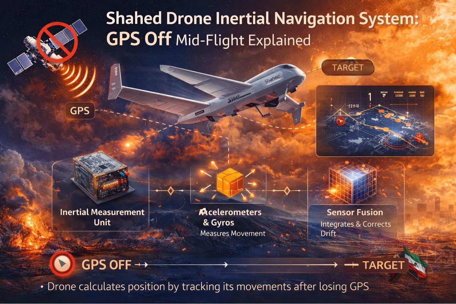
So, when a Shahed drone loses its GPS signal mid-flight, its internal inertial navigation system—the INS—takes over. It uses gyroscopes and accelerometers to basically guess its position, speed, and heading without any outside reference. This switch is built-in, a core feature for operating in contested electronic environments. But it introduces this critical, compounding error called drift. That's where the drone's *believed* location slowly, but surely, starts to diverge from where it actually is, and the error just gets worse the longer it flies.
What GPS Off Means for Navigation Accuracy
Let's be clear about the immediate handoff. The moment GPS gets jammed or spoofed, the drone stops getting those satellite timing and position corrections. Its INS kicks in and starts dead reckoning—figuring out a new position based on its last good fix, plus every little movement it's measured since. You see something similar in fleet telematics sometimes. A vehicle enters an urban canyon, and the tracker shows a smooth progression on the map... while the actual truck is just sitting idle at a red light. That discrepancy just grows until the signal comes back.
The Reality of Inertial Drift at Operational Scale
In real conditions, this drift isn't just some theory. Tiny errors in measuring acceleration, or minute gyro misalignments, they all add up—they integrate—over time. A drone flying for, say, 30 minutes after losing GPS could easily be hundreds of meters off course. For fleet managers, it's a lot like the compounding error you can get in fuel consumption reports. If engine-on detection fails and an INS-based system just assumes continuous travel, it creates phantom routes and messes up idle-time logs. That corrupts your performance data, and at scale, that's a real problem.
The Critical Mistake: Assuming INS is a Backup "GPS"
Here's the most common, and dangerous, misunderstanding: treating the inertial system like it's a seamless backup that gives you the same quality of location data. It doesn't. The INS is a short-term bridge, not a replacement. The real risk is making decisions—escalating—based on that degraded data. You could be directing interception assets to coordinates of empty sky. Or in logistics, dispatching a recovery team to the last-reported location from a stolen asset tracker that's been dead-reckoning for miles. You waste resources and, worse, critical response time.
Decision Help: When to Tune Alerts vs. Redesign Tracking
So where's the line? It's fairly clear. You can tune things—make geofences bigger, add alert delays—to account for predictable INS drift in areas where you know jamming happens. But if you absolutely need to know an asset's true location within a tight envelope, say 10 meters, after the signal goes, then an INS-augmented system just isn't enough. You need a redesign. That means looking at alternative signals or building in physical verification. This is exactly the kind of problem where platforms like gps controller try to help, by integrating multi-source validation to flag unreliable data before it sets off your automated workflows.
FAQ
Question: How does a Shahed drone know when to switch to inertial navigation?
Answer: Its flight computer is constantly checking the GPS signal integrity. When the signal strength drops below a set point, or the positions it's calculating start jumping around (which points to jamming or spoofing), it automatically cuts off the GPS receiver and falls back solely on the INS to keep following its flight path.
Question: What causes the drift in an inertial navigation system?
Answer: Drift comes from tiny, unavoidable errors in the sensors themselves. Accelerometers have bias errors. Gyroscopes have their own drift rates. These minute inaccuracies get added up—integrated—over time and distance. So without an external signal to correct it, the system's estimated position just gradually wanders off from reality.
Question: Can inertial navigation work for long distances without GPS?
Answer: Not for precise navigation, no. An INS can keep a vehicle or drone stable and flying, sure. But its positional error keeps growing the whole time. For any long-distance mission that needs accurate targeting or arrival, the drone has to periodically grab a truthful GPS signal again, or use something else like terrain matching, to reset its INS and correct all that accumulated drift.
Question: What does this mean for defending against or tracking these drones?
Answer: It opens a critical vulnerability window. If your defensive systems are trying to predict the drone's location based on its last known path, those predictions get less and less accurate over time. Effective countermeasures have to account for this drift. And tracking solutions need to recognize that INS-derived data is inherently degraded—it needs different confidence thresholds for alerts or even engagement. It's a principle you see in robust commercial fleet monitoring too.


Comments
Post a Comment